The Moment You Actually See It
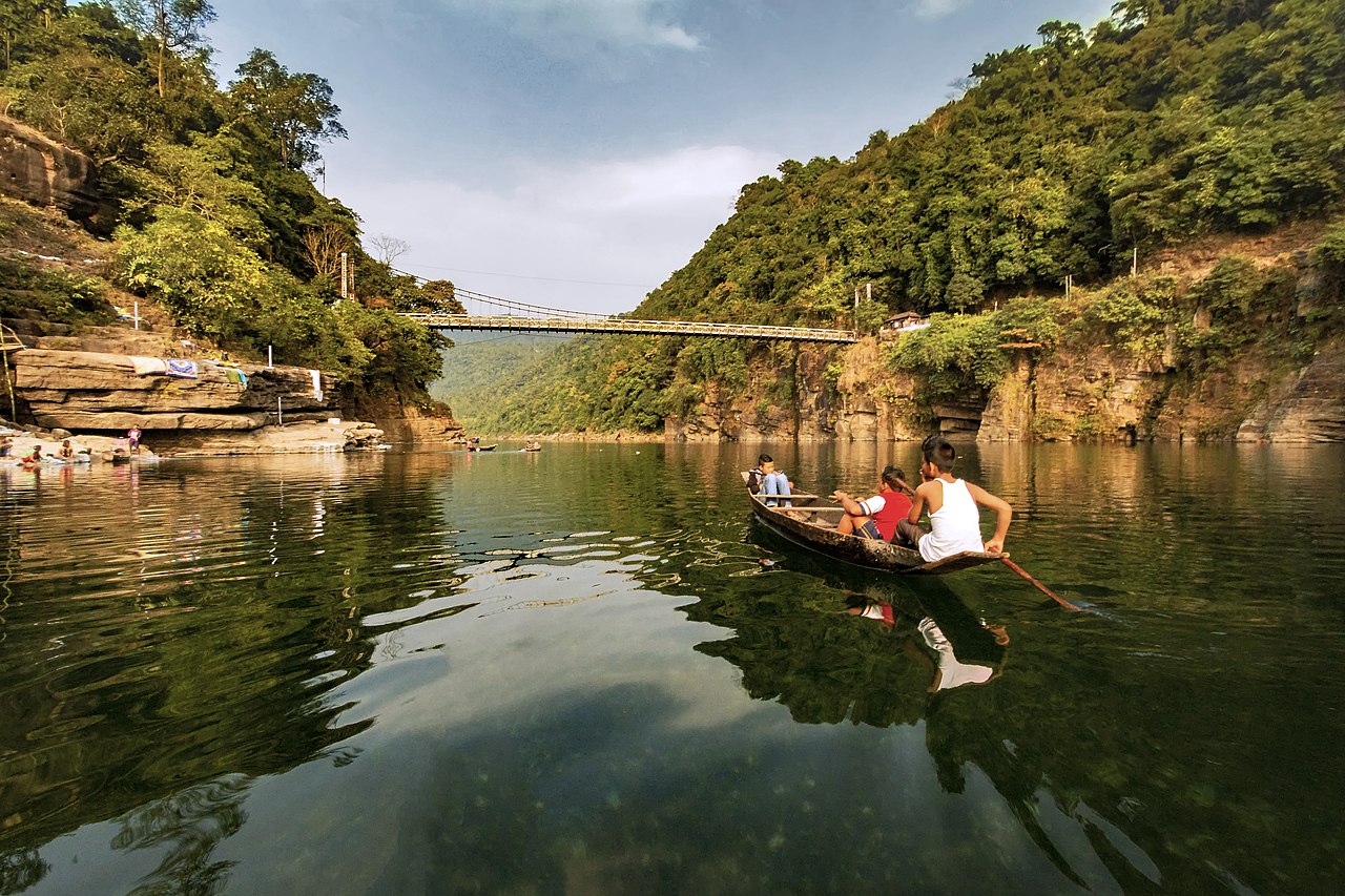
I'd seen the photographs before I saw the river in person. Everyone has — the wooden boats floating in what looks like thin air, their shadows visible on the pebble bed five or six feet below, reflected perfectly on the water's surface. I remember thinking the photos were edited. Long-exposure, colour-graded, the colours pushed to make the water look that turquoise.
They weren't. The Umngot River at Dawki genuinely looks like that. The clarity is real and slightly absurd — standing in a boat in the middle of the river, you can watch individual fish change direction over individual stones at the bottom. Depth means nothing to visibility here. It just doesn't limit what you can see.
Why Is the Water So Clear?
A few things work together. The catchment area upstream is heavily forested and sparsely populated — very little agricultural runoff, almost no industrial pollution. The limestone geology filters the water naturally. And between November and March, the water level is lower and the flow is calmer, meaning the river stirs up almost no sediment.
The Jaintia community has also maintained strict rules around the river for generations — no throwing waste, no chemical use near the banks. The village of Dawki has enforced this through community consensus rather than government mandate. It works.
When to Go — This Matters A Lot
November through March is when the river delivers on its reputation. The water is at its clearest, the level is low enough to see the bottom in most parts, and the colour shifts between aquamarine and a kind of luminous pale blue depending on cloud cover and time of day.
April and May are still reasonable. Slightly warmer, the clarity holds through April, but by May the first pre-monsoon rains start and the river begins to change.
June through October — don't bother, at least not for the river. The Umngot floods and turns brown like any other monsoon river. The boatmen don't operate during this period.
What to Actually Do
Rent a wooden rowboat from the main ghat. It costs ₹500-800 for 30 to 60 minutes and is worth every rupee. Go before 9 AM — the light at that hour penetrates the water at an angle that illuminates the riverbed, and the surface is still enough to give you perfect reflections. By 11 AM the tourist groups are arriving and the river gets choppy from all the boats.
Planning to visit?
Private cab from ₹4,500 · Local driver · Book free, pay 10% on confirm
If you have time, walk out onto the old suspension bridge at the far end of the ghat. It's one of the official India-Bangladesh border crossings, and standing on it gives you a clear view up the river with the forested hills on both sides. Photograph it in both directions.
Shnongpdeng — The Quieter Option
Three kilometres downstream from the main Dawki ghat, Shnongpdeng is a smaller village on the same river. It has the same extraordinary water, fewer crowds, and a set of adventure activities that the main ghat doesn't: cliff jumping (a solid 20-foot drop into the river that is terrifying and fun), zip-lining over the water, kayaking, and proper overnight camping on the riverbank in tents.
If you're staying the night rather than doing a day trip from Shillong, Shnongpdeng is the better base. A few small guesthouses and tent camps operate here. It has a genuine away-from-everything feeling that Dawki proper, increasingly popular, is losing a little of.
The Day Trip Combination That Works
Dawki pairs naturally with Mawlynnong, about 25 kilometres away. They're both in the lowland border area east of Meghalaya, and doing both in the same day makes geographic sense. The most efficient order is: leave Shillong early (5:30-6 AM), reach Dawki by 8:30-9 AM for the morning river light, spend two to three hours, then drive to Mawlynnong for the village and the root bridge in the afternoon, and return to Shillong by evening.
The total drive time is about five hours for the full loop. It's a long day but a satisfying one.
Getting There
Dawki is 95km from Shillong — roughly 2.5 hours by private cab. There's no reliable public transport. The road descends from Meghalaya's hills into the lowland border area, and the last 20 kilometres have a different quality of light and heat — it feels subtropical. Make sure your driver knows the early morning ghat location; there's a second ghat that's less scenic and more crowded that some drivers default to.
